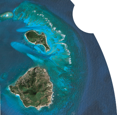
Satellite Imagery Photo

Satellite Imagery Photo

As the Caribbean Distribution Partner for DigitalGlobe, GeoOrbis offers 60cm resolution natural colour imagery and 50cm resolution panchromatic imagery, the highest commercial resolution available today.


Click on each satellite in the above image to see Detailed Technical Specifications

DigitalGlobe has established itself the world’s most prominent supplier of high-resolution commercial satellite imagery. By 2008, DigitalGlobe's constellation of satellites will be unprecedented in the commercial imaging industry, enabling commercial and government customers around the globe to access a broad selection of geospatial information products from a single source. The DigitalGlobe constellation will be capable of collecting more than 10 times the amount imagery – with industry-leading accuracy – of any current commercial imaging system. This unique position will add an unrivaled level of products and services for DigitalGlobe's customers worldwide.

Today, DigitalGlobe's QuickBird and WorldView-1 satellites are the only commercial spacecraft able to offer sub-meter resolution imagery, industry-leading geolocational accuracy, large on-board data storage, and an imaging footprint two to 10 times larger than any other commercial high-resolution satellite. QuickBird's global collection of 60 centimeter panchromatic / 2.44 meter multispectral and WorldView-1's 50-centimeter panchromatic imagery is designed to support applications ranging from map publishing and land management to asset monitoring and emergency response planning. Because DigitalGlobe's system features allow it to efficiently collect over 475 million square kilometers of imagery data annually, DigitalGlobe populates and updates its image library with impressive speed.

WorldView-1, launched September of 2007, is the most agile satellite ever flown commercially. The high-capacity, panchromatic imaging system features half-meter resolution imagery. Operating at an altitude of 496 kilometers, WorldView-1 has an average revisit time of 1.7 days and is capable of collecting up to 750,000 square kilometers (290,000 square miles) per day of half-meter imagery. The satellite is also equipped with state-of-the-art geo-location accuracy capabilities and will exhibit stunning agility with rapid targeting and efficient in-track stereo collection.

WorldView-2 is anticipated to launch in 2008. Operating at an altitude of 770 kilometers, WorldView-2 will enable DigitalGlobe to offer half-meter panchromatic resolution and 1.8-meter multispectral resolution. WorldView-2 will have an average revisit time of 1 day and will be capable of collecting up to 975,000 square kilometers (376,000 square miles) per day of half-meter imagery. The WorldView-2 system will allow DigitalGlobe to substantially expand its imagery product offerings to both commercial and international customers with a more commercially desirable, higher performance product. Added spectral diversity will provide the ability to perform precise change detection and mapping. WorldView-2 will incorporate the industry standard four multispectral bands (red, blue, green and near-infrared) and will also include four new bands (coastal, yellow, red edge, and near-infrared 2).

Affiliates - Interfleet, DigitalGlobe, ESRI, Trimble, Pixoneer Geomatics
Prior Park House, St. James, Barbados, West Indies
Phone. 246.425.1360  ·  Fax. 246.421.7900